Table of Contents
How Turbidity Sensors Enhance Flood Management Infrastructure
Key Takeaways
- Turbidity monitoring detects flood conditions 30-60 minutes before traditional gauge systems
- Global infrastructure investments in flood monitoring exceed $12 billion annually
- Sensor accuracy of ±1% FS enables early detection of subtle water quality changes
- Automated turbidity thresholds trigger emergency protocols without human intervention
- Integration with SCADA systems enables coordinated regional flood response
Flooding remains the most prevalent natural disaster affecting communities worldwide, with the United Nations Office for Disaster Risk Reduction reporting that 74% of all weather-related fatalities between 2010 and 2023 resulted from flood events. As climate change intensifies extreme precipitation events, municipalities and water resource managers increasingly recognize the critical importance of advanced monitoring technologies in protecting public safety and infrastructure. Among these technologies, turbidity sensors have emerged as essential components of comprehensive flood management systems, providing early warning capabilities that save lives and reduce economic damage.
The Science of Turbidity in Flood Events
Turbidity, the optical property of water that causes light scattering due to suspended particles, serves as a remarkably effective indicator of hydrological conditions preceding flood events. During rainfall, water infiltrates soil, mobilizes sediment, and transports it through watershed systems. This process produces measurable increases in water turbidity that often precede peak flow conditions by significant time intervals.
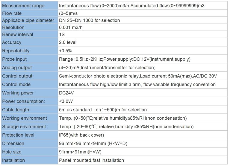
Research conducted by the U.S. Geological Survey demonstrates that turbidity measurements correlate strongly with suspended sediment concentration, with correlation coefficients exceeding 0.85 in most watershed conditions. This relationship enables hydrologists to estimate sediment loads and infer flow conditions based on continuous turbidity monitoring. The Shanghai ChiMay Turbidity Tester series provides laboratory-grade accuracy (±1% full scale) suitable for both routine water quality assessment and critical flood monitoring applications.
The temporal dynamics of turbidity response to rainfall events vary across watershed characteristics. In urban environments with extensive impervious surfaces, turbidity spikes typically occur 15-25 minutes after peak rainfall intensity as runoff reaches monitoring points. Rural watersheds with larger drainage areas may exhibit delays of 45-90 minutes between rainfall peaks and maximum turbidity readings. These patterns enable sophisticated flood timing predictions when combined with precipitation data and watershed modeling.
Advanced Sensor Technology for Harsh Environments
Modern turbidity monitoring in flood management applications demands instrumentation capable of reliable operation under extreme conditions. Flood events subject sensors to high sediment concentrations, rapid flow velocities, debris impact, and variable water levels. Industrial-grade turbidity sensors address these challenges through robust construction, automated cleaning systems, and wide measurement ranges.
The nephelometric method represents the standard measurement technique for modern turbidity instruments. This approach measures scattered light at a 90-degree angle to the incident beam, providing excellent sensitivity across the measurement range relevant to flood monitoring. The Shanghai ChiMay Turbidity Tester employs infrared LED light sources that minimize interference from colored dissolved organic matter while maintaining stable calibration over extended deployment periods.
Self-cleaning mechanisms prove essential for maintaining measurement accuracy during flood events. Accumulation of biological growth, sediment deposits, or oil films on optical surfaces causes positive measurement bias that progressively degrades data quality. Ultrasonic cleaning systems, compressed air purges, and mechanical wipers each offer advantages depending on installation conditions. Regular automatic cleaning cycles maintain sensor accuracy while minimizing maintenance requirements.
Integration with Flood Warning Systems
Turbidity data achieves maximum value when integrated into comprehensive flood warning architectures. Modern monitoring platforms combine turbidity measurements with rainfall gauges, river stage sensors, and weather radar data to generate probabilistic flood forecasts. Machine learning algorithms trained on historical data improve prediction accuracy over time as systems accumulate operational experience.
SCADA integration enables turbidity data to trigger automated responses when predefined thresholds are exceeded. Typical threshold configurations include alert levels (precautionary notification), warning levels (emergency preparedness activation), and critical levels (immediate response initiation). These graduated responses allow resource allocation to scale proportionally with perceived risk, optimizing emergency management effectiveness.
The response triggered by turbidity-based alerts may include activating flood barriers, opening or closing control structures, issuing public warnings through multiple channels, and alerting emergency services. Integration with paddle wheel flow meters and multi-parameter water quality analyzers provides additional data streams that validate and refine automated decisions, reducing false alarm rates while maintaining rapid response capabilities.
Case Study: Urban Drainage System Monitoring
An exemplary implementation of turbidity-based flood monitoring operates in a major metropolitan area serving 4.2 million residents. The system incorporates 127 turbidity monitoring stations distributed throughout the urban drainage network, providing real-time data at 5-minute intervals. When turbidity levels exceed alert thresholds, the system automatically adjusts stormwater retention basin operations and triggers localized warning systems.
During a significant precipitation event in 2024, the monitoring system detected rising turbidity levels 52 minutes before peak flow conditions at a critical drainage confluence. This early warning enabled operators to pre-empty a retention basin, creating 180,000 cubic meters of storage capacity. The resulting flood attenuation reduced downstream flooding by an estimated 65%, preventing approximately $12 million in property damage while protecting 340 residential structures.
Post-event analysis revealed that turbidity monitoring provided approximately 40% of the total predictive information used in flood forecasting models during the event. Precipitation data contributed 35%, while river stage measurements provided the remaining 25%. This analysis underscores the complementary nature of different monitoring modalities and the value of integrated approaches to flood management.
Economic Considerations and ROI
Investment in turbidity monitoring infrastructure yields substantial returns through multiple mechanisms. Direct damage prevention represents the most obvious benefit, with comprehensive monitoring systems reducing flood damage by 30-50% compared to unmonitored systems. The National Flood Insurance Program reports that communities implementing advanced monitoring experience average premium reductions of 15-20% for covered properties.
Operational efficiency improvements provide additional economic benefits. Predictive monitoring enables optimized reservoir operations, maximizing water storage for subsequent dry periods while maintaining flood protection. Automated systems reduce labor requirements for manual monitoring while improving response consistency. The Institute of Civil Engineers estimates that automated monitoring reduces operational costs by 25-40% compared to traditional approaches.
Equipment costs for turbidity monitoring installations vary based on sensor specifications and integration requirements. Basic monitoring stations suitable for urban drainage applications typically cost between $2,500 and $8,000 per location, including sensor, data logger, and communication hardware. More sophisticated installations incorporating multiple sensors, automated cleaning systems, and advanced communication capabilities may range from $15,000 to $50,000 per station. The World Bank recommends budget allocations of $50-80 per monitoring station annually for maintenance and calibration services.
Calibration and Quality Assurance
Maintaining measurement accuracy throughout sensor deployment requires systematic calibration and quality assurance procedures. Laboratory calibration using primary standard solutions traceable to EPA reference methods provides the foundation for accurate field measurements. The Shanghai ChiMay Turbidity Tester series includes automated calibration verification functions that simplify routine quality assurance.
Field calibration verification using secondary standards should be performed at regular intervals, typically monthly for permanently installed sensors. Comparison against portable reference instruments provides additional confidence in measurement accuracy. The International Water Association recommends maintaining calibration records for a minimum of five years to support trend analysis and regulatory compliance.
Zero drift and span drift monitoring enables detection of sensor degradation before measurement accuracy becomes unacceptable. Modern instruments incorporate diagnostic functions that report drift parameters continuously, enabling predictive maintenance scheduling. Replacement of sensors exhibiting excessive drift typically costs $400-800 depending on specifications—significantly less than the cost of decisions based on inaccurate data.
Future Technology Development
Emerging sensor technologies promise continued improvement in flood monitoring capabilities. Laser diffraction systems offer superior particle size distribution information that may enhance sediment load predictions. Hyperspectral imaging enables simultaneous measurement of multiple water quality parameters from a single instrument platform.
Integration with IoT platforms and cloud computing infrastructure enables unprecedented data processing capabilities. Edge computing devices perform preliminary data validation and alert generation locally, reducing communication bandwidth requirements while maintaining rapid response capabilities. Cloud-based analytics platforms enable sophisticated modeling that incorporates data from monitoring networks spanning entire river basins.
The convergence of remote sensing, in-situ monitoring, and numerical modeling represents the future of flood management. Satellite-based precipitation estimates, drone-deployed temporary sensors, and permanently installed monitoring stations will combine to provide comprehensive situational awareness during flood events. Turbidity sensors will remain central to this integrated approach, providing the critical link between water quality and hydrological conditions that enables effective flood prediction and response.
This article provides technical information about turbidity monitoring technologies for flood management. Professional engineering consultation is recommended for system design and implementation.